Saville Subway

Saville Subway formed part of the British underground works near the Hohenzollern Redoubt, south of Auchy-les-Mines. Wartime plans place it beside Saville Row and Kaiserin Trench, with adjoining passages and links towards the mining front. In 2016 the Durand Group investigated a possible way into these works. The excavations exposed a short tunnel passage, but did not establish access through the wider system.

The Hohenzollern front

The Battle of Loos, which began on 25 September 1915, left the Hohenzollern Redoubt and its surrounding trenches heavily contested. The fighting continued beyond that offensive. By March 1916 the British held the western side of the redoubt and the Germans the eastern side. On 2 March four British mines were detonated before an attack by the 12th (Eastern) Division, intended to capture the new craters and improve observation over the German positions. The National Army Museum’s account of the March fighting explains this tactical setting.

Repeated mining changed the surface trenches and the underground works beneath them. The later Saville plans therefore record a different stage of the battlefield from the October 1915 attack. The March operations provide context for the mining front; they do not establish that Saville was already in use, or identify which named subway served those attacks.

Construction and wartime use

170th Tunnelling Company’s first located Saville-specific report, dated 7 February 1917, records a dugout being prepared for electric lighting. On 10 February a Hohenzollern Redoubt mining report named “Boyau 109 (Saville)” among infantry subways under construction. These records show Saville existed by early February; they do not establish when excavation first began.

The 14 February report lists a traverse and drive X5 at Saville Tunnel, Saville Row. X5 advanced 50½ feet that week and stood at 177 feet by 28 February. Those figures describe one drive, not the whole subway. The company reported repairs and timbering in August 1917, a lamp dugout in December, and 65 feet of retimbering in January 1918. On 30 January it reported completing, lagging and fitting steps in the connection from Saville Tunnel to B shaft. April records mention B shaft at Saville Row and further tunnel work.

On 3 July 1918 the company recorded “Blocking & Fixing Doors” at Saville Tunnel. The wording does not specify their design or prove permanent closure. These entries link the tunnel to Saville Row but do not make every mining work bearing that trench name part of the subway (The National Archives, WO 95/550/5, /7 and /8).

What the wartime plans record

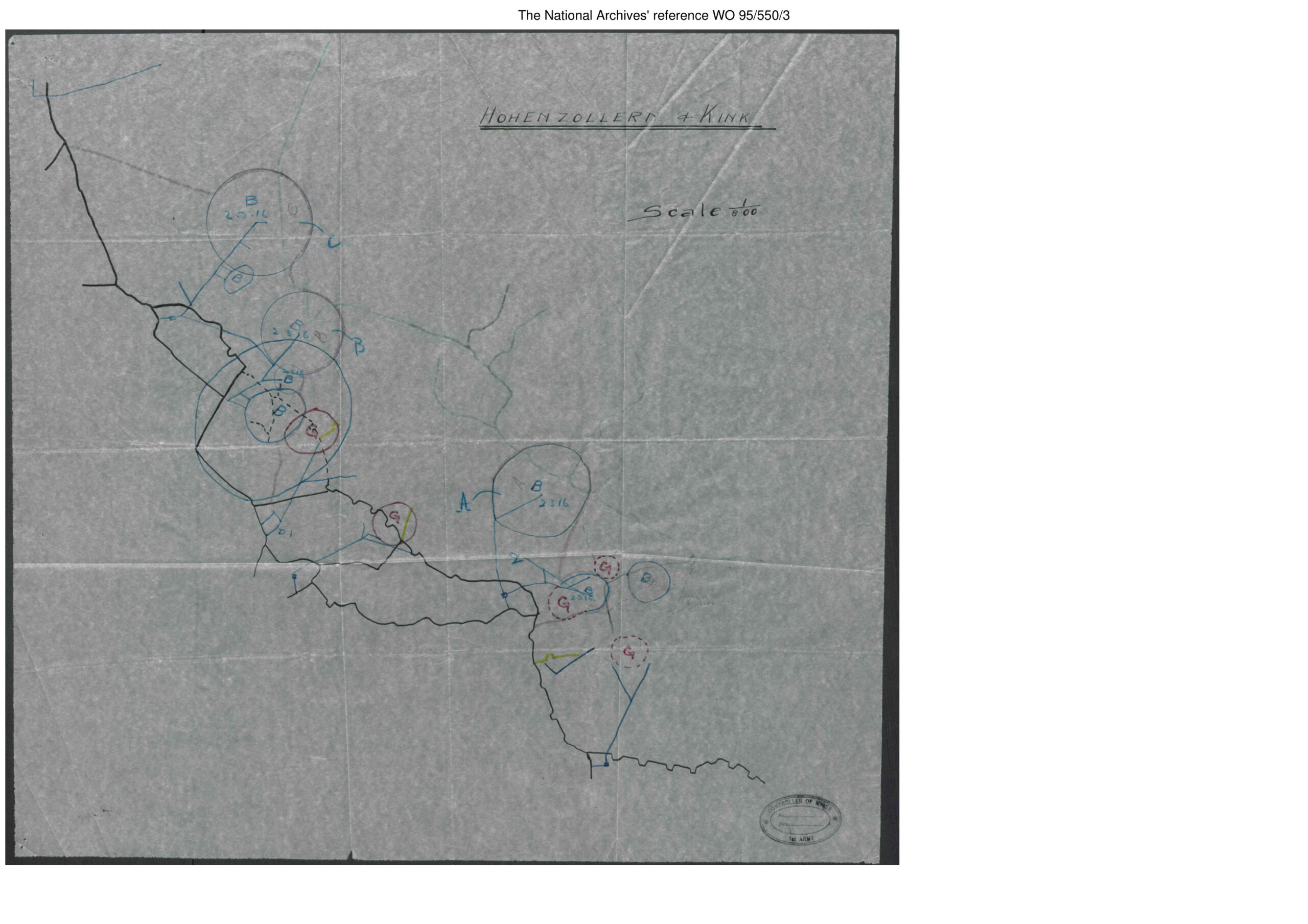
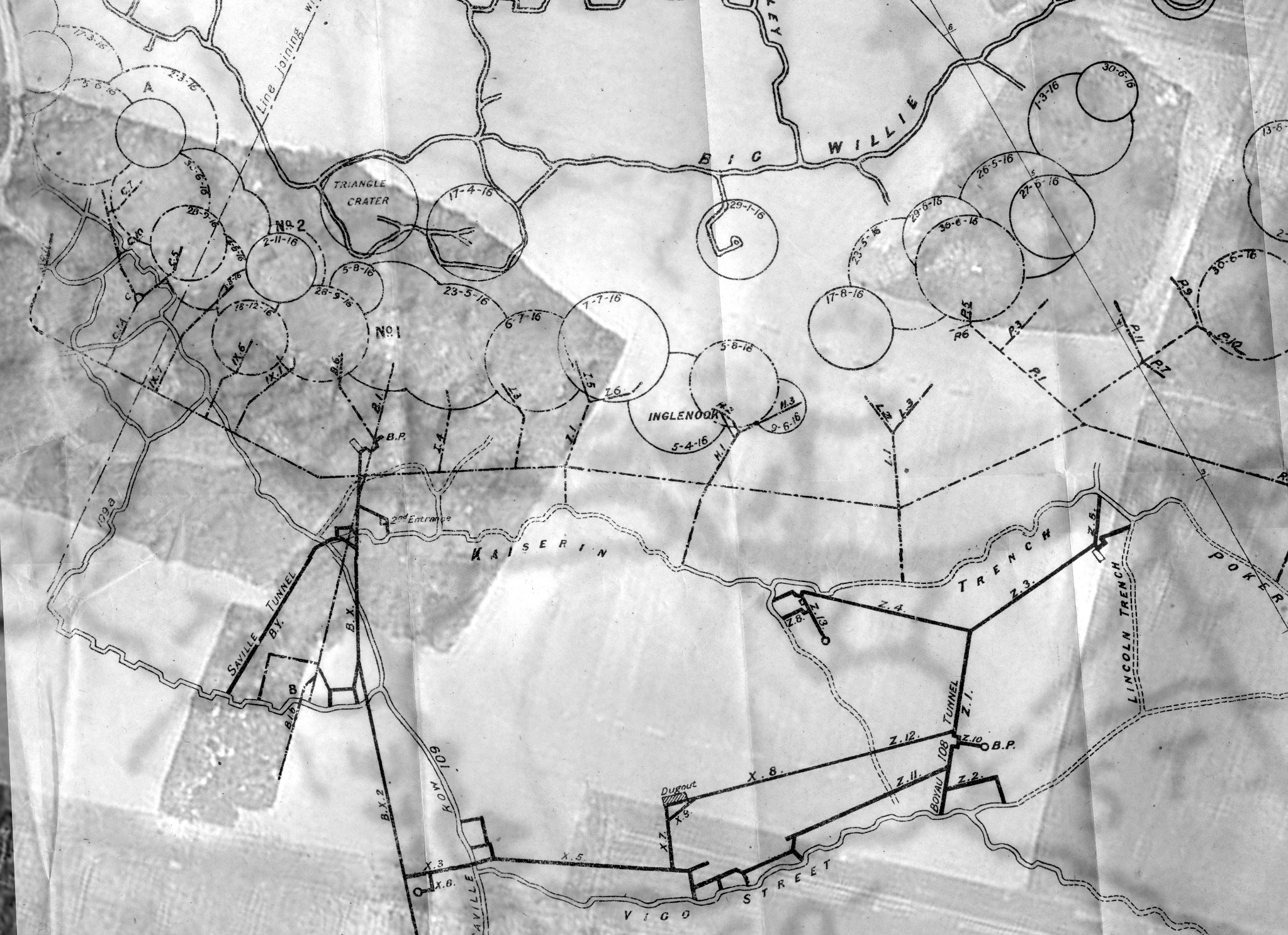
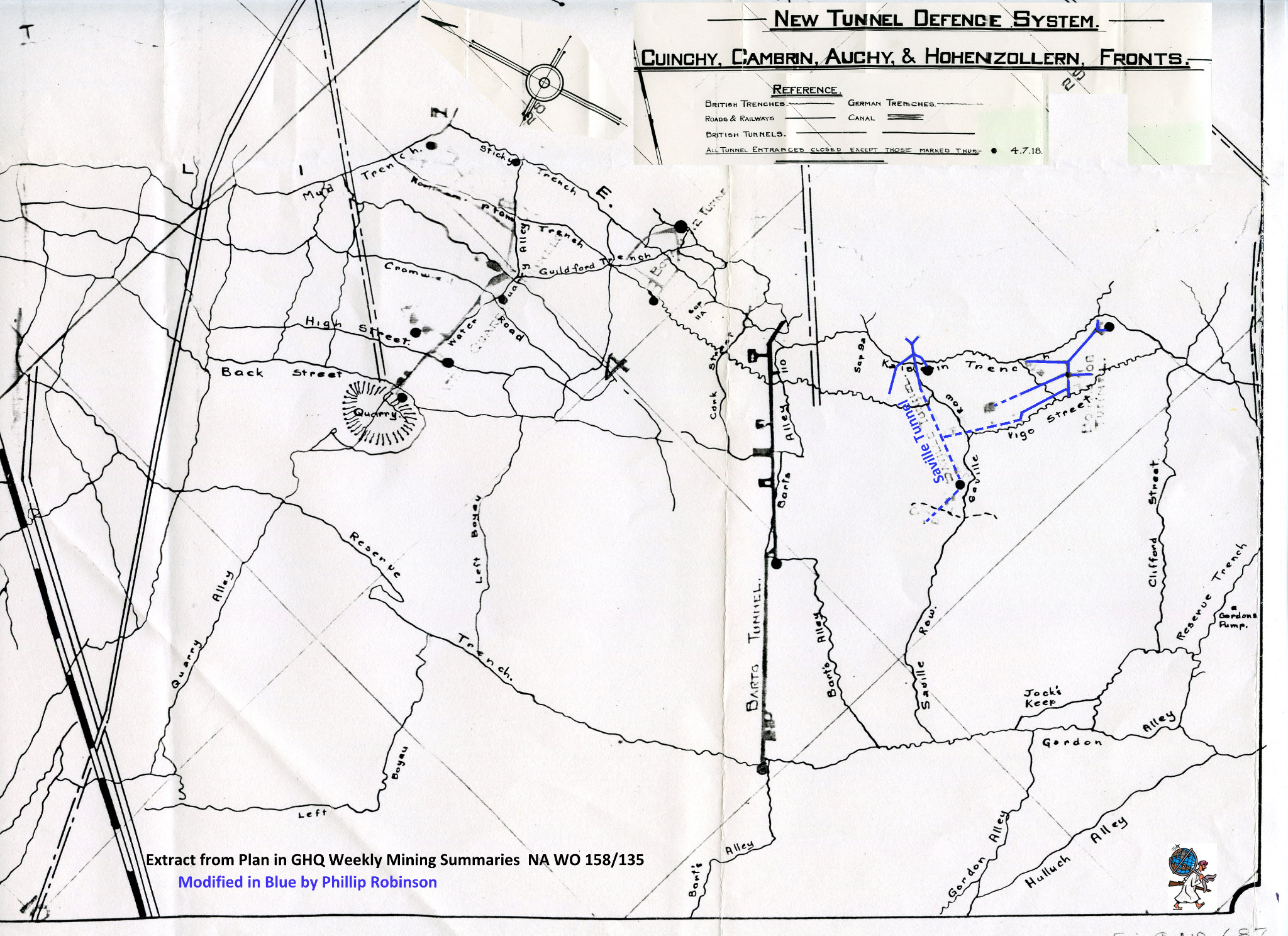
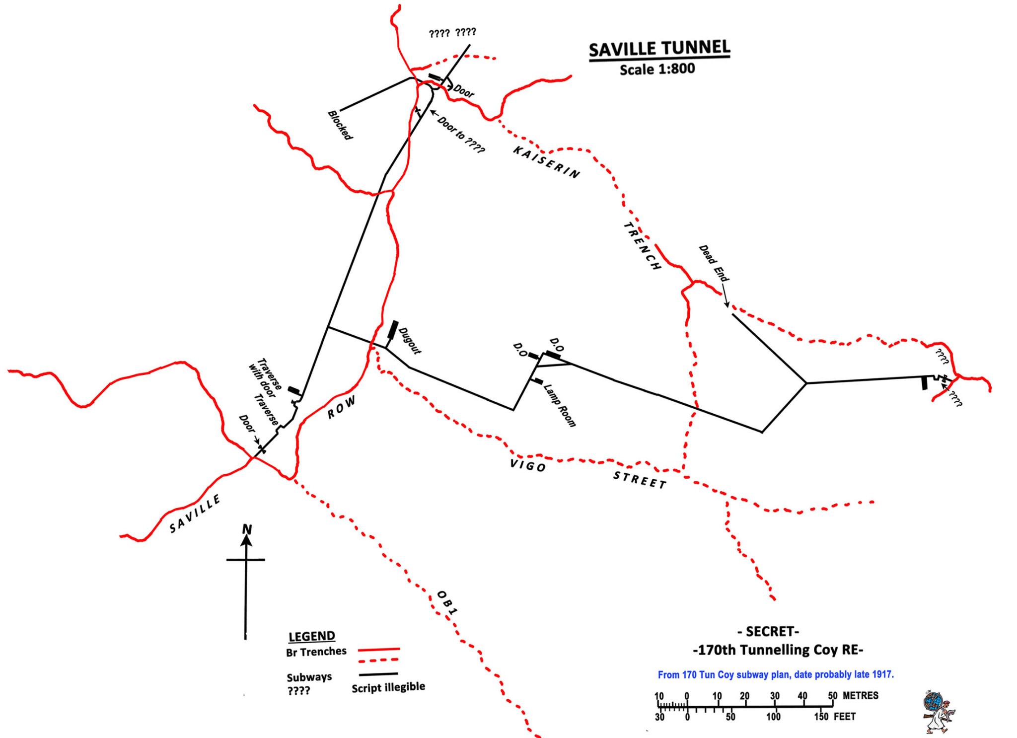
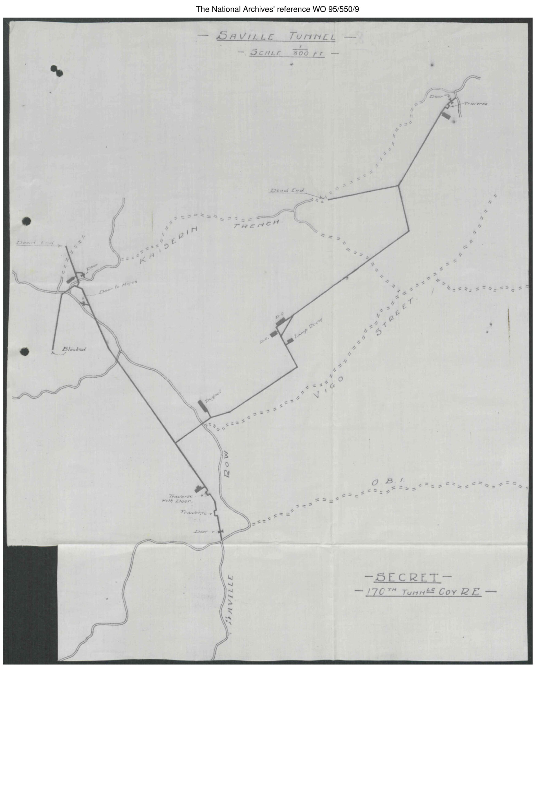
The original Saville Tunnel plan survives among 170th Tunnelling Company’s records (The National Archives, WO 95/550/9). It places a branching route between Saville Row, Kaiserin Trench, Vigo Street and O.B.1, marking a lamp room, dugouts, doors, traverses, a blocked passage and dead ends. The drawing is undated. A cover enclosing the company’s tunnel plans was handled in September 1918, which does not establish when this sheet was drawn. The Durand Group’s existing redrawing is retained below. A communication subway provided covered movement between positions, while mining galleries served the distinct tasks of approaching, listening for and attacking enemy workings. The plan shows mapped features, not when each branch was built or its present condition. A separate 170 Coy RE Front map (WO 95/550/9) sets the site among the trenches. An earlier Hohenzollern & Kink mining sketch (WO 95/550/3) shows the contested front but does not identify Saville’s later route. The existing mining plan labels Saville, B.X, B.Y and neighbouring works. The 4 July 1918 defence-system plan supplies another view; the blue Saville annotations on the Durand Group’s extract are later additions. These sources differ in date and purpose and should not be read as one surveyed layout.
Redrawn Saville-area subway plan showing Saville Row, Kaiserin Trench, Vigo Street and labelled underground chambers.
Durand Group redrawing of the undated 170th Tunnelling Company Saville Tunnel plan (The National Archives, WO 95/550/9). It depicts mapped wartime features, not a modern survey of surviving passages.
Original 170th Tunnelling Company plan of Saville Tunnel, showing branches by Saville Row, Kaiserin Trench and Vigo Street, lamp room, dugouts and blocked passages.
Original Saville Tunnel plan by 170th Tunnelling Company, Royal Engineers, undated. It marks the mapped route and features around Saville Row, Kaiserin Trench and Vigo Street. The enclosing packet bears September 1918 handling dates, not a date for this drawing. The National Archives, WO 95/550/9, PDF p. 67.
170th Tunnelling Company sketch of mining galleries around the Hohenzollern Redoubt and the Kink.
170th Tunnelling Company sketch of Hohenzollern Redoubt and the Kink, showing mining work around the contested front. It provides geographical context but does not depict Saville Tunnel’s later route. The National Archives, WO 95/550/3, PDF p. 97.
Historic mining plan showing Saville, B.X, B.Y, Kaiserin Trench and surrounding mine workings.
Historic mining map of the Hohenzollern south sector, supplied by the Durand Group. The original map date is not established here; “2016” identifies the supplied file. Saville and the B.X/B.Y works are shown in their wider mining context.
Extract of the 4 July 1918 tunnel defence plan with later blue annotations identifying the Saville area.
Extract from New Tunnel Defence System, Cuinchy, Cambrin, Auchy & Hohenzollern Fronts, 4 July 1918 (The National Archives, WO 158/135). The Durand Group’s blue annotations were added later. The extract records wartime mapping, not present-day access.

The February 2016 investigation

Between 19 and 21 February 2016, the Durand Group investigated a possible access near the Hohenzollern Redoubt as part of its Loos Salient project. Surface clearance and test excavations first examined a feature that proved to be later dumping. Attention then moved to another location indicated by local knowledge and the mapping. Mechanical excavation exposed a tunnel opening. The reports give approximate depths of about eight metres and about ten metres; these estimates are not a measured depth for the whole subway. The opening was recorded and photographed, and the main excavation was subsequently backfilled.

A soldier recovered from the battlefield

During this work on 20 February, the team encountered the remains of a British soldier. Excavation stopped while the French police and the Commonwealth War Graves Commission were contacted. The Durand Group completed the recovery on 21 February. Dr Matthew Leonard supervised the excavation, and the group passed the remains and associated material into official care. The Durand Group’s March 2016 research report identified a Leicestershire Regiment shoulder title and equipment consistent with the fighting of October 1915. It considered the 1/4th and 1/5th Battalions of 138th Infantry Brigade and the attack by the 46th (North Midland) Division on 13 October. The report did not establish an individual identity or conclusively determine the battalion. This discovery belongs to the history of the ground investigated; it does not establish that the soldier occupied Saville Subway. The report records 1908-pattern web equipment, gas-protection equipment and twelve No. 5 Mills grenades, including an example dated August 1915. The report compared these finds with brigade orders, war diaries, regimental histories and the recorded locations of earlier casualty recoveries. Several indicators favoured the 1/5th Battalion, but the report noted that its history was better documented than that of the 1/4th: a greater number of supporting indicators was not conclusive identification. These are objects associated with the battlefield recovery, rather than an assemblage recovered from inside Saville.

Research into the Leicestershire soldier

The Durand Group’s March 2016 report brings together the recovery evidence, wartime records and the historical context. It considers the soldier’s regiment and possible battalion, while explaining why a positive individual identification could not be made. Read the Leicestershire soldier research report (PDF)

Returning in May 2016

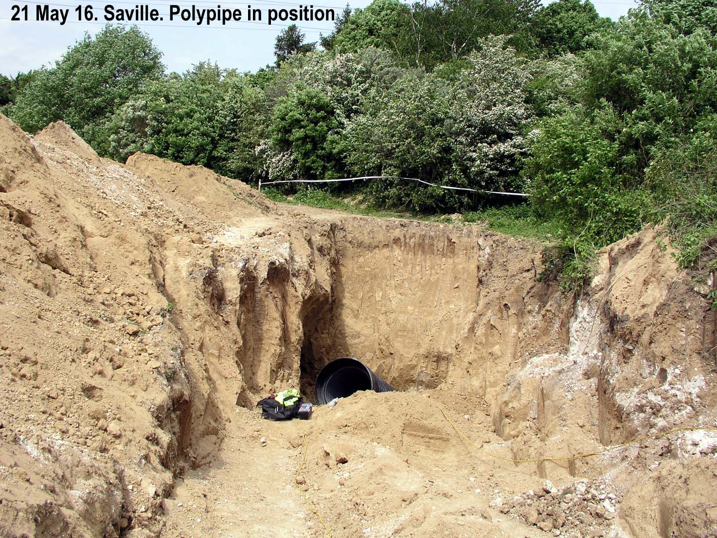
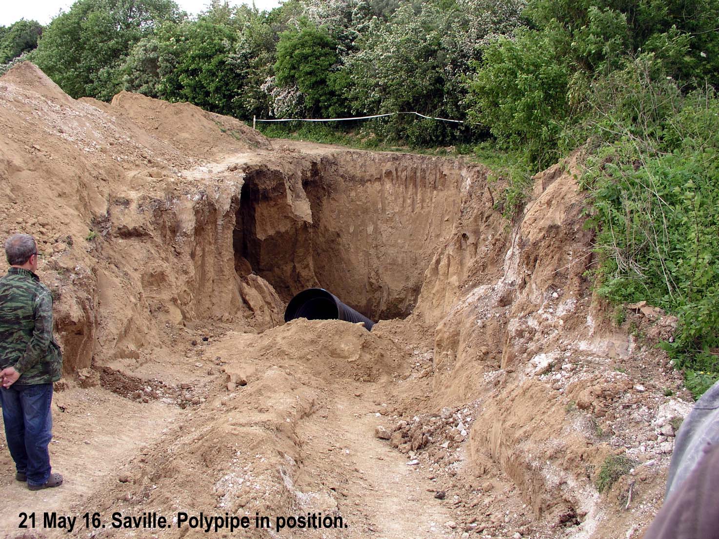
The May project aimed to establish an interim entrance to the B.X subway and, through it, investigate Saville and the mine lateral. The draft activity report records a tunnel opening at the bottom of an incline approximately six metres deep. A large polypipe liner was placed in the excavation to protect the approach against local collapse.

Excavation beyond the liner encountered material filling a vertical shaft. With progress impractical and the excavation sides crumbling, the team stopped. On Sunday the pipe was removed for use at Stansfield and the Saville excavation was backfilled. The photographs dated 21 May show this temporary engineering arrangement, rather than an entrance left available for visitors.

Which passage had been reached?

The Durand Group’s analysis of 2 June 2016 compared the February and May plots with a plan attributed to 170th Tunnelling Company. Repositioning the overlay against a trench junction produced a substantially different interpretation of the excavated opening. The exposed passage reportedly ran north for about three metres to an infilled vertical shaft, but its arrangement did not clearly match the expected junction. The group considered several explanations, including a nearby passage or an obscured connection. The analysis also noted that handheld GPS positions and the alignment of historic trench maps could differ by several metres. The evidence supports the discovery of underground fabric, but not a conclusive identification of the opening as Saville’s principal passage or a demonstrated route into B.X.
Condition and the limits of the investigation

The records describe substantial soil and clay above the chalk, disturbed ground, shaft infill and unstable excavation sides. These conditions limited the attempt to secure access. No complete modern survey of Saville resulted from the work documented here, and the short exposed passage cannot represent the full wartime layout.

The surviving record brings together military mapping, field observations and subsequent interpretation. Each has limits: a planned connection is not proof of a passage remaining open, and a modern overlay depends on its alignment. The documented investigations did not produce an extensive interior photograph sequence or a recorded Saville graffiti collection. The 2016 records describe backfilled excavations on private land; they do not establish present-day access or condition.

Sources and further reading

  • 170th Tunnelling Company, Royal Engineers, war diary, reports and contemporary drawings, The National Archives, WO 95/550/3, /5, /7, /8 and /9. The original, undated Saville Tunnel plan is in /9; the Durand Group redrawing is reproduced above. The Hohenzollern and Kink sketch in /3 provides context rather than a plan of the later Saville route.
  • GHQ Weekly Mining Summaries, The National Archives, WO 158/135: New Tunnel Defence System, Cuinchy, Cambrin, Auchy & Hohenzollern Fronts, 4 July 1918. The blue annotations on the Durand Group’s reproduced extract are later additions.
  • Mark Khan, Research Relating to the Recovery of a First World War British Soldier of the Leicestershire Regiment, March 2016. Durand Group report on the Publications page.
  • Captain J. D. Hills, The Fifth Leicestershire (1919), for Hohenzollern battlefield context, not Saville construction.
  • National Army Museum, Battle of Loos and Corporal William Cotter.